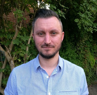
An Introduction to Dr Stephen Grebby: Assistant Professor in Earth Observation
I would like to take this opportunity to introduce myself. Firstly, I’m a local lad, born and bred in Nottingham. Amongst many other things (e.g., Rayleigh bikes, Boots the chemist, Nottingham lace), this proud city is particularly well known for its heroes, both of the mythical (i.e., Robin Hood) and sporting kind (e.g., Nottingham Forest Football Club, Torvill and Dean). Perhaps somewhat unsurprisingly, I ended up becoming a big sports fan (more watching than playing these days though), with a particular passion for my chosen football club, Nottingham Forest – I say unsurprisingly as I did grow up during the majority of the mighty Brian Clough’s reign at the club!
Whilst growing up, I also developed a strong
interest in all things space-related, so when the time came I steered my
education in that direction and studied for an MPhys degree in Physics with
Space Science and Technology at the University of Leicester (yes, on this
occasion, it is rocket science!). It was during this time that I became
interested in Earth Observation, and more specifically remote sensing. Upon
completing my undergraduate studies, I subsequently combined my interests in
remote sensing with a longstanding fascination with earth science by studying
for an MSc in Physical Geography by research – again at the University of
Leicester. My research focused on developing one of the first applications of
airborne Light Detection And Ranging (LiDAR) for mapping seismogenic faults that
were previously hidden beneath dense forest cover. It turned out that LiDAR
data is pretty cool because it can be processed to deforest the terrain
(virtually, I might add) to reveal the ground surface without actually harming
the environment. Following directly on from this, I undertook a PhD in
Geological Remote Sensing at the University of Leicester (predictably…but at
least I moved to a new department each time!). My research again focused on
helping to overcome the challenge of geological mapping in vegetated terrain,
but this time with more of an emphasis on mapping rock units using airborne
LiDAR and multispectral data.
 |
| LiDAR magic: Trees - Now you see them..... ......Now you don't! |
Following the best part of five years working at
BGS, I decided to return to academia in June by taking up the position of
Assistant Professor in Earth Observation in the Faculty of Engineering at The
University of Nottingham. My role is affiliated with the GeoEnergy Research
Centre (GERC), which is a joint venture between The University of Nottingham
and BGS. So although I am no longer employed by BGS, I have been known to continue
to haunt my old office on occasions! My current research interests are focused
on the use of satellite, airborne (manned and UAV) and ground-based Earth
Observation techniques for the exploration of geoenergy resources and the
monitoring of their exploitation. This includes identifying potential
geothermal energy resources by mapping anomalous mineral assemblages and
surface temperatures, determining key characteristics (e.g., porosity,
permeability, fracture density) for reservoir modelling, and monitoring
leakages and ground motion at sites associated with gas storage (i.e., CO2)
and energy production. When I’m not doing research, my multidisciplinary
background enables me to contribute to teaching physics-based modules in the
Department of Chemical and Environmental Engineering.
Having re-read what I written above, I realise that people could be easily fooled into thinking that I don’t get out much – after all, my career hasn’t taken me beyond a 25-mile radius of Nottingham and my day job comprises observing the Earth remotely (typically on a computer screen within the confines of my office)! However, I would just like to conclude by pointing out that this is actually some way off the truth and I do indeed enjoy exploring the big wide world! Over the past 12 years I have spent a few months in Cyprus during my PhD and have undertaken fieldwork in Greece, Slovenia and South Africa. Furthermore, I have attended numerous conferences/meetings in glamourous locations such as Vienna, San Francisco, Prague, Versailles and Rome….not bad for a predominantly desk-based job!
*You can keep up to date with GERC activities on our social media channels*

Comments
Post a Comment