Drones and Dolomites: Field work in the Picos de Europa
By Dr Veerle Vandeginste; Assistant Professor in Geochemistry
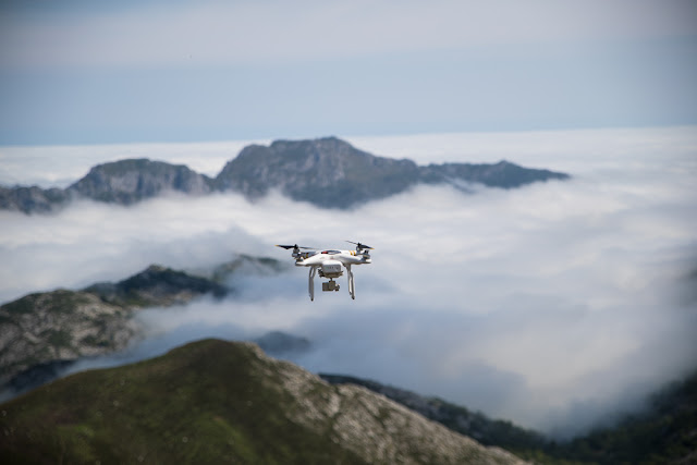
More than 80 drone flights, a total of 5359 pictures by drone, more than 80 km mountain hiking, 42 km car driving per day and a total of 828 m ground-penetrating radar survey. These figures sum up our very successful ten-day field trip in the eastern part of the Picos de Europa Mountains in northern Spain, as part of the Qatar Carbonates and Carbon Storage Research Centre project (Imperial College London).


Did you know?
Veerle previously wrote a blog for the GERC Diary highlighting her research interests and her path to her current employment. You can read it here
More than 80 drone flights, a total of 5359 pictures by drone, more than 80 km mountain hiking, 42 km car driving per day and a total of 828 m ground-penetrating radar survey. These figures sum up our very successful ten-day field trip in the eastern part of the Picos de Europa Mountains in northern Spain, as part of the Qatar Carbonates and Carbon Storage Research Centre project (Imperial College London).

The excellent weather conditions of seven and a half days of
sun, ideal for drone flights, and two and a half days of clouds and fog, good
for ground penetrating radar work contribute to this success, but above all we
had a fantastic team which made it possible to achieve significantly more than
anticipated for these ten days. The field team members were Fergus Kennedy
(Skylark Aerial Imaging, UK), Manuel Antonio Diaz Rodriguez (Falcon Air Academy,
Spain), Muhamad Yusuf Abdul Madjid (MSc Petroleum Geoscience student, Imperial
College London) and myself. With all the equipment hiking up each day an
elevation difference of 400 to 700 m in as little as 50 minutes from almost
freezing temperatures the first day to up to 30ºC during the heat wave the last
days, I think we all pushed our physical limits, except for Fergus who is used
to hiking at more than 5 km altitude and who was enthusiastically running ahead
to capture us on video and shoot amazing pictures!
 |
| Greeting from the Dolomite Hunters |
The goal of our field work was to apply novel methods to map
dolomite bodies in the Carboniferous carbonate host rocks of the Caliza de
Montaña and Picos de Europa Formations. Dolomite (calcium magnesium carbonate)
is a diagenetic product formed by interaction of magnesium rich fluids with
limestone (calcium carbonate). The transformation of limestone to dolomite
results in changes in the rock texture, hence altering porosity and
permeability characteristics. As a consequence, the presence of dolomite bodies
in carbonate host rock contributes to heterogeneity in carbonate rocks that are
potential reservoirs for hydrocarbons or carbon dioxide storage. Therefore, it
is critical to gain insight in the controls on the distribution and dimensions
of those bodies.

Previous years, we focused on mapping the dolomite in the
area near Fuente Dé (south-central Picos de Europa) in a conventional way by
tracing and walking the bodies with GPS. This year, we applied a novel way of
mapping those bodies in detail, namely by using a drone to derive the
distribution of dolomite bodies based on colour difference, in addition to
checking and confirming the dolomite composition on the ground. Despite the
challenging conditions of mountain areas to carry out drone flights for high
resolution images, our excellent drone pilot and expert made it possible to
cover a total area about five times as large in half the amount of field days
compared to the conventional mapping method last year in the less challenging
area near Fuente Dé!

Furthermore, we ran a series of tests using
ground-penetrating radar to evaluate this method for near-surface three-dimensional
mapping of the dolomite bodies, a research issue that is still a crucial
challenge up to today! Our preliminary results look very promising and Muhamad
will be working for the coming two months on processing the geophysical and remote
sensing data.
 |
| 80 drone missions equals a lot of data! |
Many more persons have been crucial in making this field
trip a success and I would like to thank everyone involved, including (but not
limited to) Bhavna Patel (QCCSRC administrator) who did an incredible job in
making all the bookings, Lindsay Holowka (GERC) for arranging Muhamad’s
placement at BGS, Jonathan Hirst (Head of School, Nottingham) and Katharine
Reid (Head of Department, Nottingham) for impressively quick replies on
research permit issues and other matters, Adam Booth (University of Leeds) for
quick feedback and help concerning the ground-penetrating radar work, Colm
Jordan (BGS) for co-supervision and remote sensing advise, Gary Hampson
(Director of MSc Petroleum Geoscience, Imperial College London) for
co-supervision and help with safety issues, and last but not least Iain Macdonald
(QCCSRC manager), Martin Blunt (QCCSRC director) and Naji Saad (Qatar
Petroleum) for advice and continuous support of this dolomite research and
making this field trip happening! Thank you all for making this work extremely
successful and an unforgettable experience!
Did you know?
Veerle previously wrote a blog for the GERC Diary highlighting her research interests and her path to her current employment. You can read it here
*You can keep up to date with GERC activities on our social media channels*
Comments
Post a Comment